

Shikoku eSIM: Best Plans for Pilgrimage Routes and Hidden Coastlines
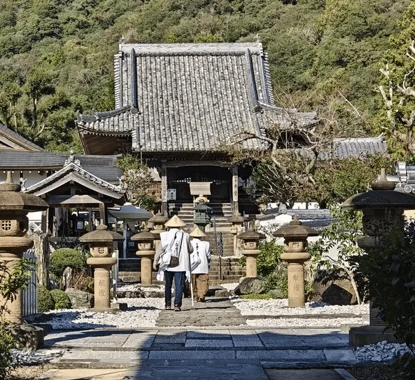
Shikoku is the Japan that rewards patience. Japan’s smallest main island — connected to Honshu by the Seto Ohashi Bridge and to the wider world by a tourism profile that remains blessedly below the radar of the standard Japan circuit — offers a travel experience defined by slowness, depth, and the kind of authentic encounter with Japanese rural and spiritual culture that more heavily visited regions increasingly struggle to provide.
The island’s defining travel narrative is the 88-temple pilgrimage — Ohenro-san — a 1,200-kilometer circuit of Buddhist temples associated with the monk Kūkai, completed by pilgrims walking in white robes with wooden staffs across Shikoku’s four prefectures. It takes six to eight weeks on foot. It is one of the world’s great pilgrimage routes. And it passes through terrain — mountain passes, rural valleys, remote cape approaches, and ancient forest paths — that creates a connectivity planning exercise quite different from Kyoto’s temple circuit.
The shikoku esim question is primarily about rural coverage endurance: the ability to maintain connectivity not just between cities, but across the long stretches of walking route, coastal road, and mountain pass that constitute the majority of a meaningful Shikoku itinerary. This guide covers the full Shikoku connectivity picture — from the four prefectural capitals to the walking pilgrimage route to the remote capes and hidden coastlines that make Shikoku one of Japan’s most rewarding slow travel destinations.
Shikoku’s Unique Appeal for Slow Travel

Shikoku’s tourism model is deliberately different from Japan’s urban highlights. The four prefectures — Tokushima, Kochi, Ehime, and Kagawa — each have distinct identities and landscapes: Tokushima’s gorge country and Awa Odori dance culture, Kochi’s Pacific-facing cape and Tosa samurai history, Ehime’s castle towns and the beloved Dogo Onsen, Kagawa’s Seto Inland Sea coastline and the Naoshima art island complex accessible from Takamatsu.
The traveler drawn to Shikoku is typically seeking something Japan’s standard circuit doesn’t provide — unmediated rural experience, spiritual depth, landscape that hasn’t been optimized for Instagram, and local hospitality that reflects genuine interest in the occasional foreign visitor rather than the efficient management of tourist crowds.
Connectivity for this traveler is a support function rather than a primary activity — navigation across unmarked rural paths, translation of temple information boards, emergency communication on long solo walking stretches, and the occasional upload of the extraordinary coastal scenery that Shikoku’s southern capes reveal.
Mobile Network Coverage Across Shikoku’s Four Prefectures
Coverage Overview
Shikoku’s population is concentrated in its four prefectural cities and along the northern coastal corridor facing the Seto Inland Sea. The interior mountain ranges — the Shikoku Mountains running east-west through the island’s core — and the Pacific-facing southern coast are significantly less populated and correspondingly less densely covered by mobile networks.
The coverage pattern across Shikoku follows the national logic: docomo shikoku provides the most comprehensive coverage including rural and mountain areas; softbank shikoku and kddi shikoku are strong in urban centers and along main transit corridors but have less coverage depth in Shikoku’s rural interior.
Tokushima Prefecture
Tokushima city and the coastal areas around it are well-covered across all carriers. The Iya Valley — one of Japan’s most dramatic mountain gorge landscapes, renowned for its vine bridges and steep-walled valley villages — is accessible from Oboke and Koboke gorge stations on the JR Dosan Line, and has Docomo coverage in the main valley areas with progressive thinning in the most remote gorge sections.
The Tokushima portion of the pilgrimage route — covering the first 23 of the 88 temples through the Kochi prefecture transition — passes through a mix of rural farmland, small town, and mountain terrain. Docomo provides the most consistent coverage along this route section.
Kochi Prefecture
Kochi is Shikoku’s largest and most rural prefecture — occupying the entire Pacific-facing southern coastline and interior. kochi esim planning covers the longest and most remote section of the pilgrimage route, and the prefecture with the most dramatic coverage contrasts: excellent in Kochi city, progressively limited along the exposed Cape Muroto and Cape Ashizuri approaches that are among the route’s most celebrated and challenging sections.
Cape Muroto — where the pilgrimage follows exposed headland paths with the Pacific Ocean on one side — has limited Docomo coverage that becomes absent at the cape’s most remote points. Cape Ashizuri — Japan’s southernmost point on Shikoku — similarly has coverage at the cape town area with limited connectivity on the clifftop pilgrimage approach.
Ehime Prefecture
Ehime is Shikoku’s most tourism-developed prefecture, anchored by Matsuyama’s combination of Japan’s oldest continuously operating onsen (Dogo Onsen), one of Japan’s best-preserved original castles (Matsuyama Castle), and the Seto Inland Sea coastal access that makes the prefecture visually compelling. matsuyama esim connectivity is strong across all carriers in the city and onsen area.
The Ehime section of the pilgrimage route — covering temples 40-65 through some of Shikoku’s most scenic mountain terrain — is the section most likely to encounter extended periods of limited or absent coverage, particularly in the mountain passes between the Nangoku and Ōzu areas. Docomo provides the most coverage continuity across Ehime’s pilgrimage mountain sections.
The Shimanami Kaidō cycling route — the spectacular 70-kilometer bridge-and-island route connecting Imabari in Ehime to Onomichi in Hiroshima — has adequate Docomo coverage across most of its island bridges and cycling paths.
Kagawa Prefecture
Kagawa is Shikoku’s smallest and most connected prefecture — compact geography, Seto Inland Sea coastal access, and proximity to the Honshu bridge connections have driven telecommunications development alongside tourism. takamatsu mobile data connectivity is the strongest of Shikoku’s four prefectural capitals across all carriers.
Naoshima — the contemporary art island accessible from Takamatsu by ferry — has adequate Docomo coverage in the main museum and port areas. The smaller art islands of the Setouchi Triennale (Teshima, Inujima, Shodoshima) have variable coverage depending on island development — Teshima has Docomo coverage in main areas; more remote islands may have limited connectivity.
The Kagawa section of the pilgrimage route — the final section covering temples 66-88 — is the most urbanized and well-covered of the four prefectural sections, ending at Kōya-san or returning to Temple 1 in Tokushima.
eSIM Tips for Pilgrims Walking the 88 Temples
The shikoku pilgrimage esim planning for walking pilgrims (henro) involves specific connectivity considerations that apply uniquely to this multi-week journey.
Navigation and Route Finding
The japan esim walking pilgrimage navigation reality is that the Ohenro route — marked by red Ohenro arrows and occasional signposts — is generally well-marked in populated areas and progressively less well-marked in mountain and rural sections where the markers themselves can be difficult to spot in poor weather or low light. The Henro Maps app and Google Maps offline tiles for Shikoku’s four prefectures are the digital tools that complement physical route markers for walking pilgrims.
Offline maps are essential preparation for the walking pilgrimage — particularly for the Kochi sections between temples 24-39 that cover the prefecture’s long rural stretches. Download offline tiles for the entire Shikoku island before beginning the walk.
Long Stretches Without WiFi
shikoku data plan considerations for walking pilgrims differ from hotel-based tourists. Pilgrims sleeping at simple pilgrim lodges (zenkonyado or shukubo temple lodgings) may not have reliable WiFi access during multi-day mountain sections. The eSIM data plan needs to cover not just daytime navigation but also evening communication, accommodation research for the following day, and the kind of quiet online presence that maintains connection with family and friends during a weeks-long solo journey.
For walking pilgrims, a generous fixed-data plan (20GB) or unlimited is the appropriate sizing — daily data consumption is moderate (navigation, messaging, occasional photo sharing) but sustained over six to eight weeks without reliable WiFi alternatives.
Emergency Communication
The most practically important connectivity function on the walking pilgrimage is emergency communication. The route traverses genuinely remote mountain sections — particularly between temples 12 and 20 in the Tokushima mountains, and in various Kochi and Ehime highland sections — where a twisted ankle or unexpected weather event creates a situation where connectivity to emergency services or rescue coordination is genuinely critical.
Docomo’s coverage advantage in rural Shikoku is not abstract for walking pilgrims — it is the difference between having a signal in a mountain emergency and not having one. The 88 temple esim connectivity recommendation for walking pilgrims is Docomo without qualification.
City Connectivity for Shikoku’s Four Capitals
Matsuyama eSIM
matsuyama esim requirements cover one of Japan’s most beloved provincial cities — with Dogo Onsen (the ancient hot spring that reputedly inspired Spirited Away), the well-preserved Matsuyama Castle on its volcanic plug above the city, and a walkable city center with excellent food culture. Coverage across all three carriers is strong throughout Matsuyama’s tourist circuit. The Dogo Onsen area, the tram route, and the castle ropeway approach are all well within comprehensive coverage zones.
Matsuyama’s shikoku onsen internet is reliable for the visitor experience at Dogo Onsen — sharing the extraordinary experience of Japan’s most historically significant bath house requires connectivity that Matsuyama’s urban infrastructure supports across all carriers.
Takamatsu Mobile Data
Takamatsu’s position as Kagawa’s prefectural capital and the gateway to the Seto Inland Sea art islands makes it a connectivity hub for the northeastern Shikoku experience. Strong coverage across all carriers in the city center, at Ritsurin Garden (one of Japan’s finest feudal gardens), and at the ferry terminals for Naoshima and the Setouchi islands.
Kochi eSIM
Kochi city’s coverage supports the visitor experience centered on Kochi Castle (one of Japan’s original castles), the Sunday market along Otesuji street, and the food culture built around katsuo (bonito) and the convivial yosakoi festival tradition. All carriers provide adequate coverage in Kochi city. The coverage reality shifts dramatically as itineraries extend into Kochi prefecture’s rural interior and southern capes.
Tokushima Internet
tokushima internet connectivity in the city is well-supported across all carriers. The Awa Odori Festival in mid-August — one of Japan’s most exuberant dance festivals — draws enormous crowds to a well-covered urban environment. Coverage along the approach to the Iya Valley is adequate on the valley floor with progressive thinning on the steep valley walls.
Data Planning for Long Stretches Without WiFi
The mobile data shikoku planning exercise for non-pilgrims taking road trips or hiking through Shikoku’s rural interior follows the same logic as the pilgrimage section, scaled to shorter durations.
Cape Muroto and Cape Ashizuri Road Trips
Both of Shikoku’s dramatic Pacific capes are accessible by road and attract visitors seeking the remote, wild coastal character that the standard Japan circuit doesn’t provide. The drive approaches to both capes pass through areas of variable coverage — adequate on the main coastal road, limited as the road reaches the exposed cape headland.
Download offline maps for the entire cape route before departure from Kochi city. Treat the cape approaches as potentially offline environments and plan accordingly — navigation via pre-downloaded tiles, emergency contacts established before departure.
Iya Valley Road Trip
The Iya Valley’s steep gorge walls create a challenging environment for signal propagation. Main valley road coverage on Docomo is present but variable. The approaches to the famous Kazurabashi vine bridges and the Iya Onsen hot spring at the valley bottom are accessible on Docomo with reduced reliability on other carriers.
Recommended Japan Sim Data Plans for Shikoku
For City-Based Shikoku Tourism
The traveler covering Matsuyama, Takamatsu, Kochi, and Tokushima — staying in city accommodation, using trains between centers, and making day trips to accessible rural sites — is adequately served by any Japan Sim Data network on a 10–15GB fixed data plan. The shikoku tourist sim for this itinerary type covers urban navigation, cultural site research, restaurant discovery, and moderate social sharing.
For Walking Pilgrims
esim for shikoku walking pilgrims: Docomo unlimited without hesitation. The combination of multi-week duration, variable coverage terrain, genuine emergency communication importance, and the sustained daily data need of a journey without reliable WiFi alternatives makes unlimited on Japan’s most extensive rural network the only appropriate specification.
For Road Trippers and Rural Explorers
Shikoku road trip and rural explorer itineraries covering the Iya Valley, Cape Muroto, Cape Ashizuri, and the pilgrimage route by car should specify Docomo for the rural coverage advantage, with data sizing toward 20GB or unlimited for the photography-intensive nature of Shikoku’s extraordinary coastal and mountain scenery.
For Naoshima and Setouchi Island Visitors
The art island visitor concentrated in Takamatsu and the Setouchi archipelago can use any carrier — the islands’ coverage on Docomo is most comprehensive, but SoftBank and KDDI are adequate for the main art island visitor experience.
According to the Japan National Tourism Organization (JNTO), the Shikoku 88-temple pilgrimage has become increasingly significant for international visitors seeking authentic Japanese spiritual and cultural experience. The GSMA identifies long-duration rural travel as a key eSIM use case, with connectivity reliability on extended routes the primary selection criterion.
Conclusion: Shikoku’s Slow Travel Deserves Reliable Coverage

Shikoku’s appeal is its unhurried depth — the 88 temples, the vine bridges, the Pacific capes, the ancient onsen, the Seto Inland Sea island art. Connectivity that works across this full geographic range, including the rural and mountain sections where Shikoku is most itself, requires the carrier with Shikoku’s most comprehensive coverage: Docomo, from Japan Sim Data, sized for the duration and data needs of whatever kind of Shikoku journey you’re making.
The shikoku connectivity guide conclusion is simple: Docomo for rural and pilgrimage itineraries; any carrier for city-only visits; offline maps always downloaded before departing urban centers. And for walking pilgrims — Docomo unlimited, activated before you put on your white robe and take the first step from Temple 1 at Ryōzen-ji.
Japan Sim Data’s Docomo-network eSIM plans for Shikoku are available at wordpress-1493298-6069223.cloudwaysapps.com.
Frequently Asked Questions
Q1: Which carrier is best for the 88-temple pilgrimage walking route?
A: Docomo is the only carrier recommendation for walking pilgrims undertaking the full 88-temple route. Its rural coverage depth across Shikoku’s four prefectures — including the mountain passes, remote cape approaches, and rural farmland sections that make up the majority of the walking route — significantly outperforms SoftBank and KDDI in the areas where connectivity matters most for safety and navigation.
Q2: Is there mobile coverage at Cape Muroto and Cape Ashizuri?
A: Both capes have Docomo coverage in the main access town areas with progressively limited connectivity on the exposed headland approach paths. Download offline maps for the full cape circuit before departing Kochi city, and treat the cape tips as potentially offline environments regardless of carrier.
Q3: What data plan size do walking pilgrims need for the full 88-temple circuit?
A: The full walking circuit takes six to eight weeks. Docomo unlimited is the appropriate plan — not because daily data consumption is high (it’s moderate), but because the sustained duration without reliable WiFi alternatives requires a plan that doesn’t impose data management anxiety on an already physically demanding journey.
Q4: Is there connectivity on the Shimanami Kaidō cycling route?
A: Yes. Docomo provides adequate coverage across most of the Shimanami Kaidō’s 70-kilometer bridge-and-island route. The main cycling paths, bridge approaches, and island rest areas are within Docomo’s coverage zone. Some remote coastal cycling paths between islands may have reduced connectivity.
Q5: Does eSIM work on the ferries to Naoshima and the Setouchi art islands?
A: Yes, with Docomo providing the most reliable connectivity during ferry crossings in the Seto Inland Sea. The short crossings from Takamatsu maintain good coverage throughout. Larger island ferries (to Shodoshima and more distant islands) may see reduced connectivity in mid-crossing positions away from coastal towers.